- Shortcut Menu
- Body Shortcut
- Main Menu Shortcut
Biodiversity and Ecosystem
TOPKorea Biodiversity Observation Network (K-BON)
TOPK-BON is a network of researchers, citizen scientists, and policymakers which coordinates various research activities, observation networks, and databases on biodiversity and ecosystems in order to enhance biodiversity observation activities in Korea. This initiative lead by NIBR (National Institute of Biological Resources), MEV KOREA.
K-BON collaborates with AP-BON and National BONs in the Asia Pacific region. Also, K-BON contributes to the global biodiversity observation activities that network partnership to the GEO BON.
The action of K-BON is species monitoring collaborated with citizen scientists, modeling and prediction of potential habitats, species/genetic research and sharing of biodiversity information. K-BON tries to link the outcomes of each level of observation with an aim to contribute to policy-making for the conservation of biodiversity in Korea (e.g. Korea’s National Biodiversity Strategy, NBSAP).
Research of survey, risk assessment and adaptation under climate change
TOPWe conduct a climate change basic monitoring at terrestrial, freshwater and estuary ecosystem to identify threat factor such as a biodiversity decrease and endangered species increase of ecosystem under climate change.
We conduct a pollination timing impact of pollination insect to provide scientific evidence for management and preservation of a pollination function under climate change.
To provide an adaptation measure based on the risk assessment, we conduct a climate change risk assessment and impact prediction by an ecosystem type.
Water Resources
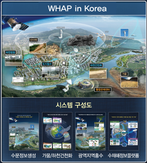
TOPRecently, water related disasters such as drought and flood have been increasing rapidly due to climate change, and technologies that can respond pre-emptively and scientifically through the fusion of advanced technologies are being continuously developed.
Recently, the frequency of large-scale water related disasters has increased due to global warming and abnormal climate, and although the scale of the damage is becoming increasingly larger and wider, there is insufficient infrastructure to respond quickly to a wide range of disasters.
In this way, there are increasingly more cases in which the damages cannot be accurately detected and predicted due to frequent floods and droughts in local cities. Therefore, scientific and efficient disaster response and system construction are emerging as urgent and top priority national tasks.
As part of the 'Water Management Research Project' of the Ministry of Environment in 2014, the government will systematically collect and analyze water-related disaster information on the Korean Peninsula and other parts of the world, and to develop technologies that can provide relevant information to government departments and the private sector. We are promoting the 'Technology Disaster Information Platform Convergence Technology Research' project.
Especially, a global water hub will be constructed through a platform to produce and provide information related to water resources and water disasters in the Asian region that includes the Korean peninsula. In this way, it is expected that the technology development that can analyze and predict real-time information related to weather in advance to handles diverse water disasters such as drought, flood and dry stream phenomenon, which are directly connected with peoples’ lives, is expected to be completed.
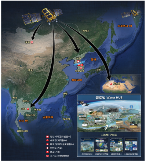
(Source: K-Water Institute)
Cities and National Lands
TOPPlanning Support System for Urban and Territorial Planning
TOPThe cities and land use created on the earth have a great impact on the sustainability of the planet. Residential, commercial, industrial and recreational activities, and roads, airports, harbors, bridges, etc., which are the basis for them, require destruction or transformation of existing ecosystems.
In order to develop the city and the land use with minimal impact on the global ecosystem, we must comprehensively analyze big data from global level satellite image data to urban and individual units. It allows to see relationship between cities and land use. By analyzing data from across the globe, you can see how cities and territories are expanding and how they affect the planet.
The KOPSS (KOrea Planning Support System) is a decision support system that provides the information needed for city and land use planning. Five models are developed: a regional planning support model that can diagnose the balanced development status of the land, a land use planning support model that finds the best land for various conditions such as accessibility and land price, an urban renewal support model to find an aged region that needs to be regenerated, and a landscape planning support model that analyzes the impact of new developments on the surrounding landscape in three dimensions, a public facility planning support model to find areas where public facilities are lacking, and resort development.
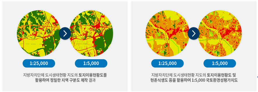
Comprehensive value evaluation map of national land environment (national land environmental evaluation map)
TOPMulti-faceted efforts are essential in managing ecologically healthy and environmentally stable land environment so that living together with the land environment can be fulfilled.
The Ministry of the Environment prepares a national environmental evaluation report that comprehensively assesses the conservation value of the country for the precautionary and eco-friendly management of the land environment, and it is being utilized in the national land plan, environmental plan, and environmental effect evaluation.
The evaluation map of the Ministry of the Environment is a map showing the evaluation of the relative preservation value of the country in five grades based on 57 legal evaluation items and 8 environmental and ecological evaluation items using the spatial environmental information collected from each department. Since 2005, 1:25,000 maps have been provided nationwide, and the large scale 1:5,000 maps, have been in service for some local governments since 2017. It is preparing evaluation criteria to reflect the national interest in clean air and water in the future evaluation of the land environment.
Energy
TOPEvaluation of renewable energy resources through satellite remote sensing
TOPCurrently, the whole world is passing through the age of energy conversion. If the existing energy conversion considered new energy source, the present energy conversion is considering sustainability. As a solution to this problem, the spread of renewable energy is accelerating with the smart energy demand management based on IoT.
Renewable energy using natural energy such as the sun and wind power is very volatile in terms of time and space depending on the weather conditions. Therefore, for the renewable energy generation project, priority should be given to accurate resource assessment. The International Renewable Energy Agency (IRENA) collects various resource maps that can be used for the evaluation of renewable energy resources to support the supply of renewable energy in developing countries and services them free of charge. The Korea Institute of Energy Research (KERI) has advanced the resource evaluation based on existing ground observation, and has produced a new renewable energy resource map on the Korean peninsula using satellite remote sensing data such as Chollian and Arirang, and provides it free of charge through the map book and web service.
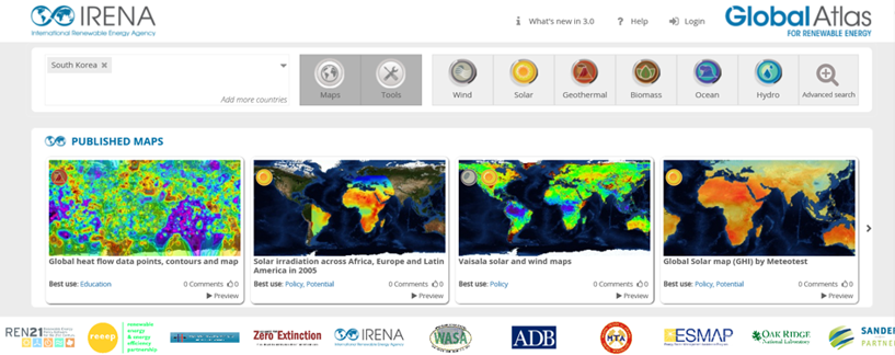
IRENA Global Atlas (https://www.irena.org/globalatlas)
The Korea Institute of Energy Research (KERI) New Renewable Energy Resource Map (www.kier-solar.org)
Resources
TOPRemote sensing for geological survey and mineral exploration
TOPThe KIGAM (Korea Institute of Geoscience and Mineral Resources) is conducting a surface geological survey in the Tsogttsetsii copper mineralization zone of Omnogobi Province, southern Mongolia, with the MRPAM (Mineral Resources and Petroleum Authority of Mongolia) since 2017. In 2018, the distribution of altered and sulphate minerals related to copper mineralization on the surface was mapped using LANDSAT ETM+, ASTER, WorldView-3 satellite data, and drone-based images. The results of the remote sensing analysis were verified by geological field survey and acquisition of hyperspectral data of minerals in the potential area confirmed from satellite analysis.
Also, KIGAM has been conducting geological investigation and exploration activities in Zambia, Tanzania and Mozambique as part of the African Minerals Geoscience Initiative (AMGI) project with the African Union and the World Bank since 2016. In the 2018 survey, Sentinel-1 (SAR), Sentinel-2 (multispectral), Landsat 8 (multispectral) images and DEM data were analyzed for the identification of geologic structures such as faults and for the distribution mapping of surface altered minerals in Tanzania. The geologic remote sensing technology was used for the planning of geological field survey, aeronautical geophysical survey and for the upgrade of existing geological information.
Weather/Climate
TOPUnderstanding water circulation and climate change through satellite observation data analysis
TOPAnalyze quantitatively water circulation-soil moisture, evapotranspiration, and precipitation using global satellite observations and understand interactions. The drought situation in Korea can be discovered by providing evapotranspiration of Chollian Satellite No. 1 and soil moisture information of microwave satellite at the Hydrological Weather Drought Information System (hydro.kma.go.kr) of the Korea Meteorological Administration. It will provide information on precipitation in East Asia, which is a composite of Chollian Satellite No. 2 and microwave satellite data from 2020.
Long-term satellite observations can be used to quantitatively analyze changes such as changes in Arctic sea ice, sea surface temperature, albedo, and solar irradiance to determine the cause of climate change on the Korean peninsula. It provides satellite observation data and model prediction information of Arctic ice melting area and roughness through Meteorological Agency's Arctic Ice Melting Monitoring System (nmsc.kma.go.kr). Moreover, it will produce and provide long-term satellite weather data of Chollian Satellite No. 1 and No. 2A to assist the quantitative analysis of climate change in East Asia.
Ocean
TOPMonitoring ocean environment using ocean satellites
TOPDevelopment of ocean satellite sensors starts from Ocean Scanning Multi-spectral Imager (OSMI), the optical sensor onboard in KOMPSAT-1 (launched in Dec. 1999). In 2010, the world’s first ocean color sensor on the geostationary orbit, Geostationary Ocean Color Imager (GOCI) was launched successfully, and the data has been used for various scientific and operational applications. Research on the calibration/validation and applications was mainly conducted under the initiatives of Korea Ocean Satellite Center (KOSC) in Korea Institute of Ocean Science and Technology (KIOST), contributing to various maritime issues in Korea such as red tide, floating algae, sea fog detection, fine dust quantification, etc. GOCI data is also being distributed to public via the KOSC homepage as well as through the Naver thematic map service (Korea’s leading portal service).
The GOCI processing techniques and product algorithms have been developed through the research projects titled “Application research on the geostationary ocean color satellite (first and second phase)” for more than 10 years, where various international research activities were performed (Korea-US joint field campaign between KIOST and NASA, 2016, installation of 2 AERONET-OC, member institute in international ocean color coordinating group (IOCCG), and hosting International Ocean Color Science Meeting (IOCS-2019), etc.
The Korea Ministry of Oceans and Fisheries plan to launch the second GOCI (GOCI-II) in late 2019, and promoting other polar-orbiting satellites for ocean monitoring through the government’s earth observing program named “next generation middle-size satellites”.
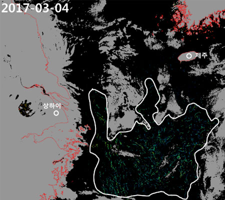
Figure 1. (left) Red tide (Cochlodinium Polykrikoides) outbreak in summer, 2013 captured by GOCI images, and (right) massive brown algae (Sargassum honeri) patches detected in East China Sea by GOCI. (image credit : Korea Ocean Satellite Center, KIOST)
Environment
TOPMonitoring air quallity in East Asia with GEMS (Geostationary Environmental Monitoring Spectrometer)
TOPAir pollution problems and climate change occur over East Asia due to the rapid industrialization and global warming.
Geostationary Environment Monitoring Spectrometer (GEMS), which will be launched for the first time in the world, will observe air pollutants or short-lived climate pollutants more than 8 times every day, such as ozone, aerosol, sulfur dioxide, nitrogen dioxide, and formaldehyde.
After launch, GEMS satellite data will contribute to improving the accuracy of air quality forecast mainly. In addition, advanced research, such as long-range transport effects, climate change monitoring, will be conducted through continuous monitoring of the air pollutants with GEMS. It will be utilized for the environmental policy establishment to solve air pollution issues.
In particular, formation flying with TEMPO of the USA and Sentinel-4 of Europe is expected to create synergistic effects, and Korea will be able to discuss air environmental issues with satellite data as a leader in international relationship.

-
Ministry of Science and ICT, Government Complex-Gwacheon, 47, Gwanmun-ro, Gwacheon-si, Gyeonggi-do 13809, KOREA
TEL: 02-2181-0396
Copyright © 2018 KGEO. ALL Rights Reserved.